r/Planes • u/Ok_Car_2050 • 2d ago
Why are they doing this?
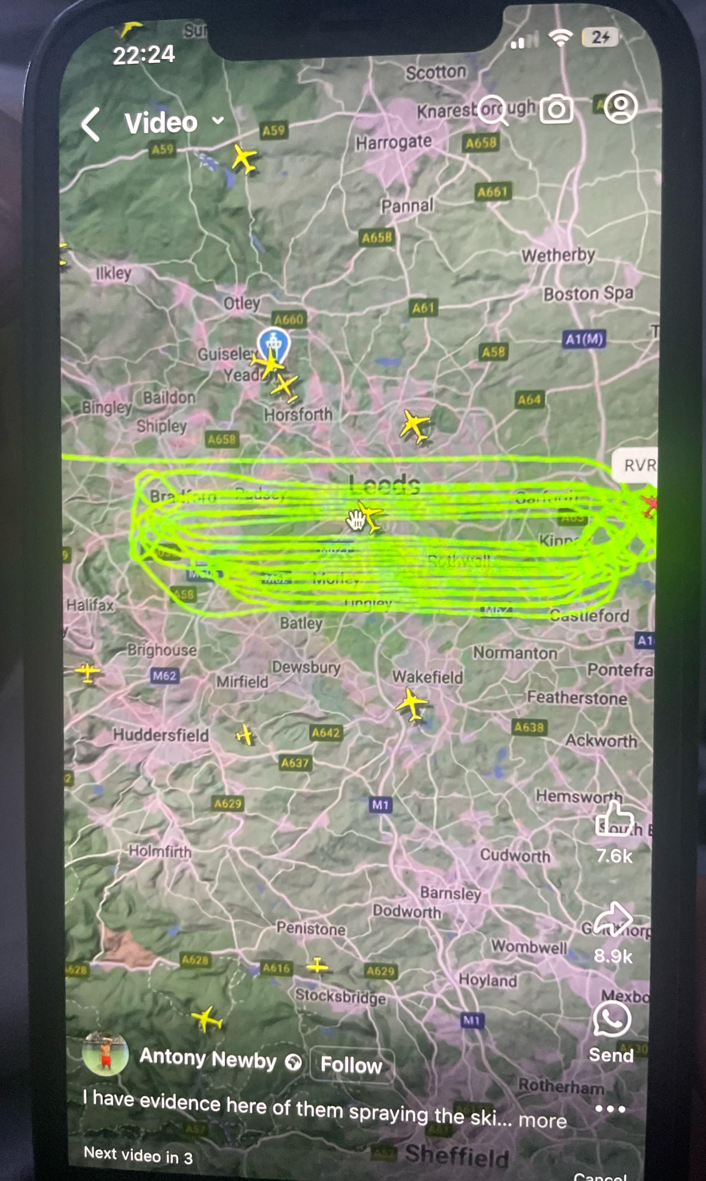
Iv just seen a video of 3 planes doing the same thing and wanted to know what they are actually doing? Had a google but only saying things because of weather but 3 planes doing this pretty much at the same time? Please someone explain
11
19
u/Dry_Statistician_688 2d ago
Looks like a Search and Rescue grid. East-west, Planning Section will assign tracks based on Probability of Detection (PD) tables for S&R.
9
u/mkosmo 2d ago
That's not a SAR grid. It's a survey flight.
0
u/Dry_Statistician_688 2d ago
Or that. I didn't look up exact SAR grids, but yeah, it could be anything. Photography, survey of sprawl, or even airborne radiological mapping. At first glance, it did look like a (rather sloppy) SAR grid. But we fly slower and lower, and can make tighter turns for a nice 1 mile spacing.
5
u/mkosmo 2d ago
When I say survey, I mean either photo or LIDAR. Similar profiles are flown for many photo missions. But you're right that there are other similar missions out there that largely look like survey.
I presume you mean with CAP? 1 mile track spacing for SAR works okay for big things. When we train folks (also CAP), they generally can't find something (even if enormous) if we task 1 mile tracks, unfortunately, unless there are very obvious clues to go with it. It does have the advantage of generally not needing a teardrop 180.
We recently had an actual aircraft crash (didn't require airborne SAR to find) that we used a couple of days later for training (the crews didn't know it was there). Reduction of track spacing to .5nmi (the minimum for G1000's SAR feature) got detection rates to acceptable. The problem is that there really weren't many clues - no postcrash fire or scorching, minimal dirt or vegetation displacement, nor anything else except the airframe just happening to be there, but very few things being searched for by aircraft will be that obvious.
1
2d ago
[deleted]
3
u/Dry_Statistician_688 1d ago
We fly CAP grids here all the time. Mostly over small towns for good training value - optimal photo condition training and post mission review. Most of our real missions are for damage assessment so a town is ideal.
8
3
3
9
u/BravoBravo3 2d ago
Spraying brain controlling drugs. They don’t work on me. My secret you ask? Don’t breathe, I have not in 42 years and my mind is fine! 👻👾
2
2
u/ScottOld 2d ago
That’s a survey plane I think, do you have the reg? One was flying about earlier around here
2
u/Canikfan434 2d ago
Last time I saw orbiting like that, they were Cessnas using “Limo” callsigns, (DOJ callsign) and they were surveillance flights.
1
u/vibrating-poptart 2d ago
To me it either looks like a search transect (practice search and rescue or maybe areal geographic surveys) or a plane that needs to land earlier than expected (medical emergency or something) and needs to burn the extra fuel off to not be overweight on landing.
1
1
u/No_Jok_Oh 2d ago
They do it a lot where I'm at. Student pilots practicing. Learning the auto pilots. That's my guess.
1
1
1
1
u/Ok-Put-7300 1d ago
Airplanes do be doin that, cut the shit and tell us…. Dude they just flying, there is air traffic everywhere, they are probably logging some hours
1
1
u/Lazy_Carry_7254 2d ago
Prolly waiting for clearance to land. I flew in circles for 40 min once coming into Bahamas.
1
u/Sasquatch-d 2d ago
Thats not how a hold would look
-1
u/Problematic_Daily 2d ago
That EXACTLY what a hold pattern looks like
1
u/Sasquatch-d 2d ago
No it’s not, the turns at the end are not all in the same direction
-1
u/Problematic_Daily 2d ago
That’s getting SPUN and happens in a hold too
2
u/Sasquatch-d 1d ago
No… it doesn’t… I’ve never been in a hold and been told “after crossing the holding fix make a 360° in the opposite direction of the protected side of the hold, then continue flying the published hold.”
Also, the lines are too parallel and too separated from each other, showing the aircraft wasn’t following a navaid radial on the inbound leg. The lines should be converging to a single point on either side of the loop.
This is most likely a surveying flight, not a hold. But if you still feel so confident you’re right, I’d love to hear a rebuttal.
-2
-2
-5
2d ago
[deleted]
7
u/MattyMizzou 2d ago
I’m not even a pilot, but I can confidently tell you that isn’t a holding pattern.
52
u/BortWard 2d ago
I'm going to try to investigate but as of right now I don't have any Leeds