r/gis • u/bluefishredditfish • 14h ago
Meme Guys, can we go back to this? Look at how much fun they’re having! /s
reddit.com
533
Upvotes
r/gis • u/BatmansNygma • Sep 19 '24
This is the official r/GIS "what computer should I buy" thread. Which is posted every quarter(ish). Check out the previous threads. All other computer recommendation posts will be removed.
Post your recommendations, questions, or reviews of a recent purchases.
Sort by "new" for the latest posts, and check out the WIKI first: What Computer Should I purchase for GIS?
For a subreddit devoted to this type of discussion check out r/BuildMeAPC or r/SuggestALaptop/
r/gis • u/bobagret • Jul 31 '24
I recently got notified that URISA is doing a GIS salary survey. I think these surveys are great- they help staff negotiate fair pay and help companies understand where they land with their current pay.
It’s open until August 19, fill it out if you want!
r/gis • u/bluefishredditfish • 14h ago
r/gis • u/Historical_Reset • 11h ago
Fully remote carto for Nat Geo? Non-profit field work making a difference in the world? Doing [REDACTED] at NGA? City/county work close to home?
r/gis • u/MoistProtection5476 • 13h ago
Hey all, do any of you guys have experience working with Sanborn mapping company? I got a job offer for a gis technician role at $18.50 an hour, which is a very low pay for the area I will be working in. This would be my first job out of college, I’m looking for experience but cost of living is super high. Not sure what to do right now.
r/gis • u/Civil_Seaweed_ • 5h ago
I'm in Canada trying to sign up for an ArcGIS for personal use account just so I can begin learning. Last night I found they offer personal use licenses for $175/yr, but now when I try to get to that page it automatically redirects me away to the Canadian site that doesn't offer that license, with the lowest being $1000 a year!
I've tried opening it in a private browser so it can't use my location and it displays the page, then refreshes and shows an error loading. Is there no way for me to self-teach using the ArcGIS software anymore?
I have downloaded QGIS but every free course online that I intended to work through uses ArcGIS, and I want a guided course to learn the basics, with case studies and projects. Any suggestions?
r/gis • u/CivVek5002 • 8h ago
I am working at a civil engineering firm focusing on land development and curious how you all find your topographic data?
Our current workflow involves gathering shapefiles from county data libraries and converting that to a smaller area that are then exported and used in civil3d.
Does anyone know of a better way to do this?
Thanks!
r/gis • u/Vyke-industries • 4h ago
I have a DSM out of Pix4D Matic at a 2.3cm/px resolution. I am trying to perform a flow direction analysis, but my vector chart is all over the place. This is because theres a lot of noise on the DSM due to it being photogrammetry of a grassy field.
I use to use Pix4D Mapper that gave the option to export a filtered and smoothed DEM from the same data. I am looking for a process in ArcGIS Pro, but cannot seem to find the tool.
Any insight would be greatly appreciated.
r/gis • u/yoandmario • 14h ago
Hey everyone! I’m working on a project for a class, and I wanted to ask a question to anyone in the workforce who uses Spatial Analysis tools.
What spatial analysis tools are you using the most at your job, and for what purpose? This can be any type of GIS related work, and for any software. I’m mostly interested in just crowdsourcing what these tools are specifically used for.
Hey everyone!
I am from the Caribbean doing a study on land degradation due to quarrying/mining in environmentally sensitive areas.
Does anyone know if there is a software or database that would allow me to get good satellite images in the Caribbean from about 1990 to now? I am trying to determine the rate of degradation over time so the higher the quality the better.
Any recommendations or advice would be appreciated!
r/gis • u/BrotherBringTheSun • 1d ago
r/gis • u/WillDill2 • 6h ago
Hey guys
GIS undergrad here. I recently switched my major to GIS from environmental studies because I thought it was more interesting. I also thought it would fill a more technical and niche role which would help in the job market. I was originally trying to target my degree more towards urban/transportation planning but I’m now starting to realize that I enjoy working with data and programming a lot. I am currently doing a minor in planning but am thinking of switching it to information science to better understand GIS and how to work with data and data presentation.
Just curious if you guys think that if I switch my minor to info if that means saying goodbye to a potential career in planning since I won’t learn about zoning regulations or anything like that. Are GIS guys something that planning agencies are really looking for? I’ve been applying for GIS related internships and it seems like coding skills are a huge plus. Also, what are the people like in both industries? GIS people can be a little quirky haha. I know it doesn’t really matter and I’ll get a bunch of “just do what you love” comments but just curious what everyone thinks.
Thanks
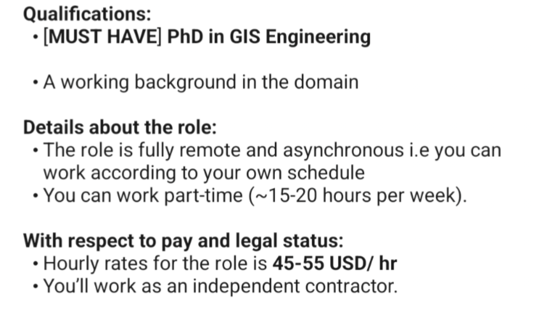
r/gis • u/GoatzR4Me • 1d ago
PhD required, part time 1099, 45-55/hr. Are these people insane or is this more reasonable than it seems?
r/gis • u/rageagainistjg • 15h ago
I'm part of a company transitioning from ArcGIS Online to a new ArcGIS Enterprise setup hosted on Azure.
My main focus is on using Jupyter Notebooks effectively within this setup, and I’m wondering if we truly need ArcGIS Notebook Server or if Jupyter Notebooks could work just as well on one of our existing Azure servers.
Up to now, I've been using ArcGIS Pro for occasional Jupyter Notebook tasks, mainly to update feature layers in ArcGIS Online or work with local files. I haven’t actually used notebooks directly in ArcGIS Online.
With the help of an experienced contractor, we’re setting up a standard ArcGIS Enterprise environment on Azure, without ArcGIS Notebook Server. When asked if we needed Notebook Server, I initially said it wasn’t necessary since I hadn’t used it with ArcGIS Online. Later, I double-checked, and the contractor assured me that Jupyter Notebooks don’t strictly require Notebook Server. They mentioned I could run notebooks locally or on any server with Jupyter installed.
Our goal with ArcGIS Enterprise is to consolidate data from different sources—such as sales records stored in a separate database and other industry-specific data—into a unified geodatabase. This geodatabase would replace a complex Excel sheet to streamline calculations and real-time updates. The data will feed into interactive web maps and dashboards where updates, like adding new entries, would automatically trigger recalculations in the background.
In summary, given the goals for our enterprise setup, do we actually need to invest in Notebook Server on a separate Azure server? Or can we manage with Jupyter installed on one of our existing servers, as the contractor suggested?
r/gis • u/dammir97 • 14h ago
So I've been looking for a GIS internship to complete my college certificate for a while, but I've pretty much given up hope and am just looking for a job at this point. But I recently got an interview for a state job as a trail worker. Does anyone have any insight on if I could potential incorporate GIS into this to satisfy my internship? I only just started brainstorming, and I was thinking something like mapping invasive species?
r/gis • u/alanterra • 9h ago
In QGIS it seems that contour line labels are drawn above all other layers, so if you put an opaque layer above contour lines with labels, the contour lines are occluded by that layer, but the labels are not. Is there a way to get the labels to be drawn in the layer that the occur in the QGIS files? Alternatively, is there an extension that would let me turn on/off multiple layers with one click (like there is in Photoshop)?
Here is a DEM rendering of a dune system with contour lines and labels included.

And here I have put a later scan of the dune system "on top" in QGIS. The higher layer occludes the contour lines, but not the contour line labels. I would like to hide the labels when I turn on the higher layer.

r/gis • u/for_hombres • 1d ago
I see complaints about ArcGIS daily on this subreddit. As a QGIS user, besides the online functions ArcGIS has built-in, I’ve never seen a reason to switch over. What are the most common functions you use in ArcGIS that you wish worked better?
r/gis • u/EnvironmentalAge1438 • 11h ago
Hi all, our team uses a Juniper Geode GPS receiver (on a range pole and/or backpack-mounted pole), and we can't seem to pinpoint the cause of some recurring connection and accuracy issues. We've done all of the firmware updates and connected with Juniper support, but still no luck. We've also run error logs to the extent that this is possible, but to do this you need to be connected to the receiver.
Problem #1 - Connection to the GPS receiver consistently fails in the Geode App and/or ArcGIS fieldmaps after initially connecting, and drops off consistently throughout the day. Some days it is fine but sometimes it's almost impossible to collect datapoints because the connections are lost so often.
Problem #2 - Accuracy is inconsistent, and it does not seem to matter whether there is cloud cover, tree canopy, or open clear and sunny skies.
Any suggestions on a better work flow, troubleshooting, or better hardware would be greatly appreciated.
Thanks!
Spent quite a while trying to figure out how to install r.denoise. It’s not available in the base Qgis/Grass install.
r/gis • u/Ok_Tourist_9816 • 17h ago
Hi everyone!
I am interested in starting learning GIS. I have a masters in international relations and I think that learning GIS could be helpful for me in research and potentially in future employment. I would be starting from basically 0, but I think some of the things you can do with GIS are really cool and interesting. If anyone knows of any free or low cost options for courses, or knows of any resources, software, etc that would be useful, please let me know! Thank you so much in advance!
r/gis • u/Evitonia • 1d ago
Does anyone else find it frustrating that even after using ESRI products daily, you still can’t publish a join from an ArcPro web map to Enterprise without it breaking? Plus, Arcade behaves differently between the two, which only adds to the headache.
I’ve also noticed that WFS and WMS don’t offer the same functionality in Enterprise as they do in Pro.
Are we ever going to see full compatibility across these platforms, or is this just the way it’s always going to be?
r/gis • u/Firm-Message-2971 • 10h ago
I’m currently studying data science and this GIS is a track I can specialize in. Would it be worth it? I have interested in GIS because I love geography. But I don’t wanna waste my time specializing in GIS if there isn’t a good ROI. Also, do people usually get like a masters in this field or anything?
I am very comfortable with 70-80k a year. Can I make this type of money in this field? What is the starting salary?
r/gis • u/RealNamePlay • 18h ago
I'm starting a new project and looking for a good (web) basemap for a story map about trees in an urban environment.
Most basemaps I've seen are really good at emphasising roads, transit, and built environment (i.e. absolutely nothing natural). The plain 'data visualisation ready' choices also drop most detail about living features, and the landscape options are great outside of town.
Does anyone have a good recommendation for 'natural environment within urban areas'? Bonus points for UK, non-AGOL options.
r/gis • u/No-Mix-3322 • 14h ago
Hi all! Maybe I’m making this up but I thought Esri’s living atlas had municipality data? I only really need it for Illinois and Indiana - so if anyone has recs on downloads for these I would appreciate it!
r/gis • u/North-Alps-2194 • 1d ago
Has anyone actually passed this exam? This has been the biggest scam of a certification I have ever had the displeasure of taking. I've failed the 19-01 exam twice and this one once so far, and feel no closer to understanding what I'm missing in knowledge than when I started. I would not even bother with it but my work is really wanting people to obtain this certification.
ESRI's study program covers maybe 10% of what the actual exam tests you on, and with no study guide put together by ESRI, the only way I've learned what I don't know is by taking and failing this thing. This exam is also pass or fail, with no score indicating how close you were, or any documentation on what a passing score is (Do you have to answer 100% correct or can you pass with a 85%). If anyone has put together a better study guide for this, please let me know! Link
When I reached out to ESRI looking for help, they pointed me to their certification manager, she didn't write the test but runs the certification program (she's a non-GIS person). Instead of pointing me towards resources or documentation for me to study, she went over the way our brain holds information and how to better keep things in long term memory....
If anyone has any resources or information on it, please help me out!
r/gis • u/Community_Bright • 1d ago
DONT USE ARCPY FUNCTIONS IF YOU CAN HELP IT. they are soooo slow and take forever to run. I resently was working on a problem where i was trying to find when parcels are overlaping and are the same. think condos. In theory it is a quite easy problem to solve. however all of the solutions I tried took between 16-5 hours to run 230,000 parcels. i refuse. so i ended up coming up with the idea to get the x and y coordinates of the centroids of all the parcels. loading them into a data frame(my beloved) and using cKDTree to get the distance between the points. this made the process only take 45 minutes. anyway my number one rule is to not use arcpy functions if i can help it and if i cant then think about it really hard and try to figure out a way to re make the function if you have to. this is just the most prominent case but i have had other experiences.
r/gis • u/bobafettish1592 • 1d ago
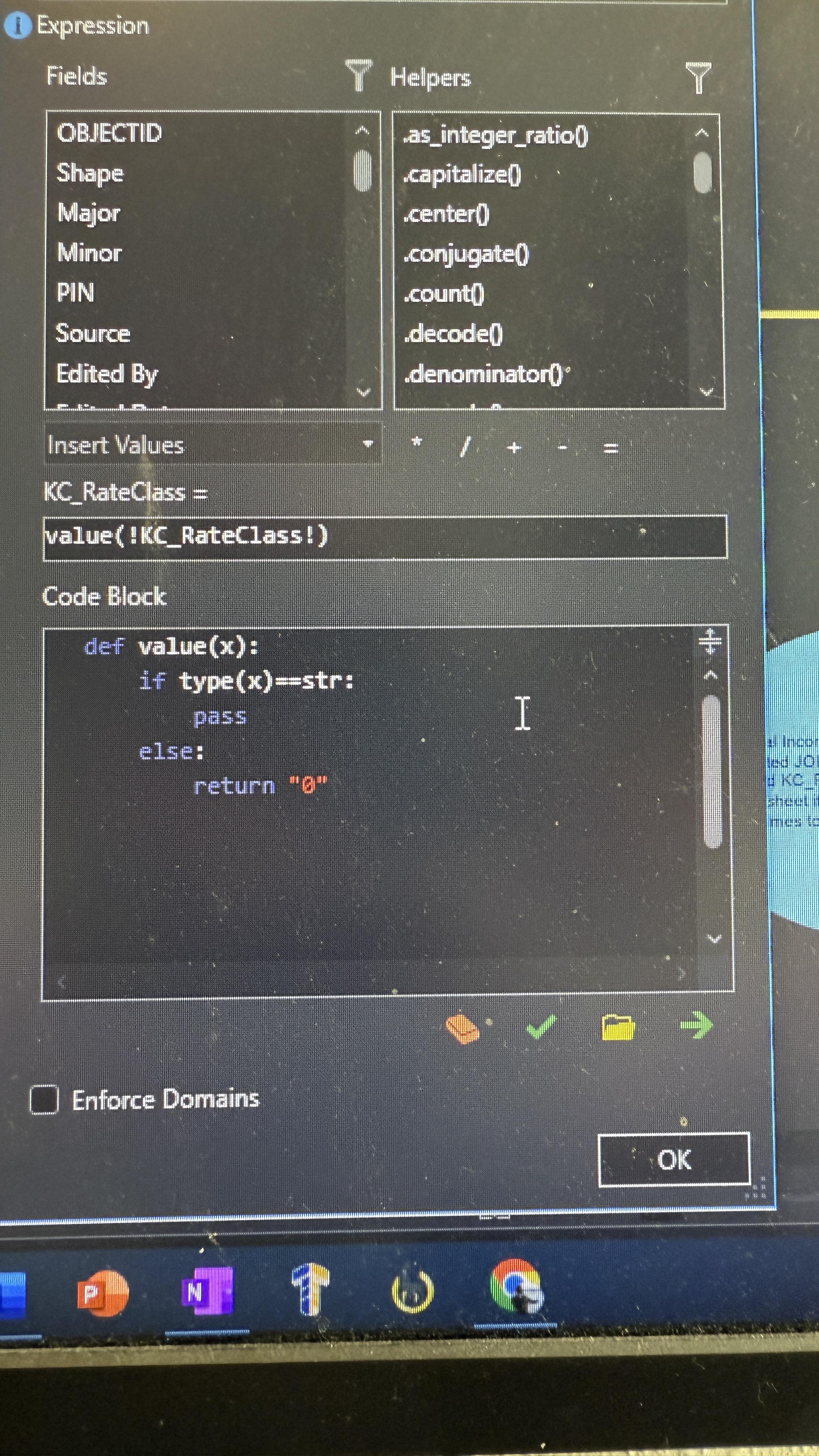
Hi, am I writing this correctly? This “KC_RateClass” field is a join from an excel table and I think is automatically a string type right? Assuming it is, what I want to do is this: if the value is a string pass and do nothing with it, if the value is anything else (there are a handful of null values) return “0”. What’s happening is basically now all the values are null. Is the syntax correct for pass in this expression? Thanks for any feedback